Amahuagaychu, Peru, F.A.
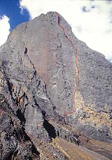
On 11 June 2004, Mauro Florit, Massimo Sacchi and Marco Sterni reached the previously unclimbed summit of Amahuagaychu 5134m, in the Cordillera Blanca, Peru, via their new route (500m, VII, A2).
| On 11 June 2004, Mauro Florit, Massimo Sacchi and Marco Sterni reached the previously unclimbed summit of Amahuagaychu 5134m, in the Cordillera Blanca, Peru, via their new route (500m, VII, A2). The three left Italy on 27 May for the exploration expedition and, after having "discovered" their wall by chance on a photo on a wall, immediately headed to the remote Quilloc valley. It's at this point that we let Mauro Florit take control: Mountaineering - exploration expedition Perú 2004 by Mauro Florit "Perù isn't only all about the Esfinge, the super-popular wall above Laguna Paron. Thanks to a photo hung on the wall in the Don Bosco Missionary at Marcarà , we discovered our objective, a virgin wall on an unclimbed mountain. This is what mountaineers did 100 years ago. These are things that make you drop everything and head off immediately. From Huaraz we travelled south, past the village Olleros, then we followed the quebrada (valley) Uquian to Sacracancha at 4030m. We continued east to quebrada Quilloc, from where we followed tracks to beneath the face and establish our Base Camp at 4532m. Our mountain has two different names for the local herdsman in quechua: Amahuagaychu, which means “don't cry” and Huaketsa Punta, which can be translated as “sharp point” due to the particular shape of the mountain. The summit, which we believe to be unclimbed, was not even marked on the local maps. The west face is characterised by an imposing triangular wall, 500m high and split into two in the middle by an obvious corner. This is the logical line of ascent and, without interruptions, leads to the summit We needed ten days to climb the route, also because we wanted to leave it with fixed ropes so that our Peruvian friends Blas Eleazar, Lucio Foliman and Michel Araya from the “Escuela de alta montana Don Bosco en los Andes” could reach the summit. The route is 500m long and graded VII, A2. We reached the top on 11 June, and our GPS reading placed the summit at 5134m. The route is dedicated to Eder Sabino Cacha, a young mountain guide who died in an avalanche the day before we topped out. Our expedition relied on the fundamental help of the “Escuela de alta montana Don Bosco en los Andes” based in Marcara’ and run by Giancarlo Sardini (OMG)." |
|
Latest news
Expo / News
Expo / Products
Ever since its market launch, the Barryvox avalanche transceiver has been among the most reliable transceivers in the world.
Minimalist, lightweight jacket
Leather approach shoes designed to guarantee maximum stability and grip even on the roughest terrain.
The C.A.M.P. ED Evo Line: technical, lightweight, compact range of down sleeping bags.
Comfortable harness for gym and outdoor climbing
An ultralight two-person tent for trekking and biking.


 Copia link


