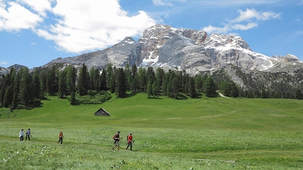
Lago di Braies - Croda del Becco - Croda del Becco

 1 / 4
1 / 4 Planetmountain


This beautiful and interesting walk coincides with the start of the classic Dolomite Alta Via nr. 1 traverse from the Lago di Braies to Belluno and crosses through one of the largest natural parks in the South Tyrol, the uncontaminated Fanes - Sénes ? Braies area. The itinerary starts and finishes at beautiful Lake Braies and follows a long, varied and simple round-trek. This can be carried out by spending a night at Rifugio Biella, the highest point reached on this outing, located at the foot of Croda del Becco. An early morning start after a night spent in the mountain hut leads down to the crytal clear waters, which constantly reflect the towering walls high above. The mountain environment in the upper section of the walk is arid and scree, typical of the Dolomite plateaus, while lower down near the Braies basin it transforms into luscious green forests. Weather conditions permitting, expert walkers can reach the summit of Croda del Becco via the classic line used by the first ascentionists. A fixed cable now protects the most exposed section. The panorama from the summit is priceless for those who opt for this alternative.
From Cortina d?Ampezzo take the highway SS 51 to Dobbiaco. Continue left towards Brunico, and then follow signs for Lago di Braies.
ItineraryDay 1 From Lago di Bràies (1489 m) walk along the road to the southern tip of the lake to then continue along a mule path (signposted Nr. 1) to climb up the basin. Croda del Becco, to the west, dominates this ascent. At the top walk through two large rocks to enter into the narrow valley called ?Buco del Giovo? (2034m, 2 hours). The itinerary continues along path no. 1 and offers a glimpse onto the small lake Giovo down below (2026m), before reaching a semicircular wall. Continue past some rocky steps and reach the so-called ?Forno?, a narrow gully that runs between Pizzo Forno and Monte Muro. Follow this past large boulders and then zigzag upwards to the col Forcella Sora Forno (2388 m, 1.45 hours from Buco del Giovo; 3.45 hours from the start). Continue down to reach Rifugio Biella in about a quarter of an hour, and settle in for the night (2327m, 4 hours from the start). Day 2 From Rifugio Biella descend south-west, following path No. 6 to where a path leads off right at about 2260m. Follow this west beneath the western flank of the Croda del Becco. The path continues along the northern tip of Alpe di Sénes to reach the rocky path No. 23 at 2247m. this leads north to Forcella Riodalato (2331m, circa 1.30 hours from the Rifugio Biella). After the col the path descends rapidly down Valle Riodalato, steeply at first down a series of zigzags beneath the rocky walls, then straight through the wide Cadin di Sénnes valley which is overlooked by the Cadin di Sénes and the Col de Ricegon. Reach an opening and cross the river close to the characteristic slabby Punte Riodalato outcrops, before descending into Valle Riodalato. The path leads through the thick forest on the right hand side of the river down to a beautiful hut at Alpe Foresta (1590m). After a short break continue along path No. 19 easily down to Lago di Braies (1489 m, 2 - 2.30 hours circa from Forcella Riodalato; 3,30 - 4 hours circa from Rifugio Biella).
GearNormal walking gear
Maps/Bibliography1:25.000, Tabacco, Foglio 31 ?Dolomiti di Bràies ? Marebbe?; 1:25.000, Kompass, Foglio 637 ?Alta Pusteria?.
DifficultyOuting with some sections suitable for experts only.
 Comments


Show more in Sexten Dolomites


 Copia link
 Emanuele Falghera

