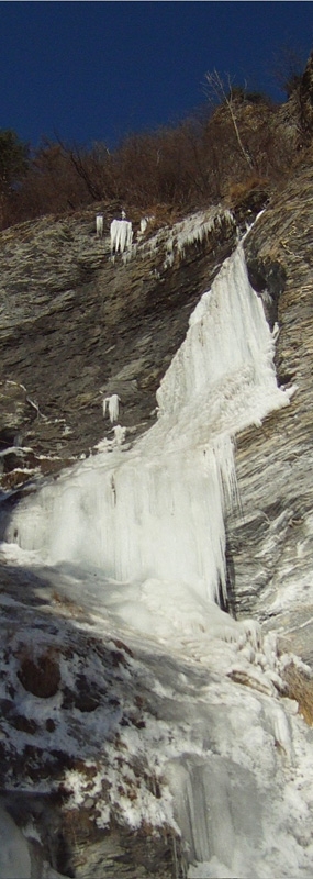
Cascata di Rochemolles - Vallone di Rochemolles

 1 / 6
1 / 6
Cascata di Rochemolles: Cascata di Rochemolles - pitch 4 (arch. E. Bonfanti)
 Planetmountain
Beauty


First ascent
M. Bernardi, G.C. Grassi, F. Salino - 20/12/1980
By
Elio Bonfanti
Orientation
ENE
Length
225m
Height
1550m
Difficulty
III/3+
Beautiful icefall which unfortunately cannot be climbed very often as the right conditions are dictated by a series of different variables. The icefall can only be climbed in safety after an extended freeze and little fresh snow on the upper slopes.
Getting there
From Turin take the motorway towards Frejus, exit at Bardonecchia and follow signs for Rochemolles. Drive along the valley bottom and then continue up the steep and winding road to Rochemolles. Park circa 1 km before reaching the village, close to a small bridge from where you can see the imposing icefall on the other side of the valley. Access
Walk along the river bed which leads to the main stream. Wade through this, then coast along the slope to reach the start of the route in circa 10 minutes.
Itinerary
P1: A first drip, usually not particularly well-formed, leads to a section where the angle eases off. After having easily climbed this enter into a short but very beautiful 70° - 75° wedged gully. Belay at the end of this on the left (60m, peg and bolt).
P2: From here climb directly upwards past ice which plasters some 45° slabs and which lead to an amphitheatre at the base of the next nice steep section. Belay here (50m, bolt).
P3: From the belay climb left up the nice face via 80° sections to reach a comfortable ledge (55m, bolt).
P4: Climb the final steep section up thin 85° - 90° ice to finish wedged in between the summit rocks (60m, bolt). Descent
Abseil down the route using the belays used during the ascent. Take slings to substiture the in-situ tat. Gear
Full ice climbing rack, including some short ice screws.
 Comments
No comments yet...
Beauty


First ascent
M. Bernardi, G.C. Grassi, F. Salino - 20/12/1980
By
Elio Bonfanti
Orientation
ENE
Length
225m
Height
1550m
Difficulty
III/3+
Routes in the same mountain group
Show more in Val di Susa


 Copia link
 Elio Bonfanti

