
 1 / 1
1 / 1
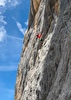
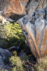
Google Trekker at the Grand Canyon, USA
 Google
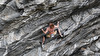
Google maps Switzerland's paths
Google and the Swiss Alpine Club (CAS) have launched a project to map a series of paths in Switzerland with the Google Trekker technology.

 Copia link

Google's project was started a few years ago: to map not only all the world's maps with its Street View technology but also digitalise the most beautiful and remote places on this planet. For some time now it's been possible to wander - online of course - around Everest Base Camp, but on Tuesday Google announced that it will join forces with Club Alpin Suisse to map a series of paths that lead up to some mountain huts.
This is the first time the US internet giant is providing its technology in Switzerland, in particular the rucksack that makes the 360° panoramas that can then be viewed on Google Maps, such as the Grand Canyon in Arizona. The first clips will be made in the Bernese and Valais Alps and we cannot but wish happy and safe walking: the backpacks weigh 18 kg!
Latest news
13/07/2026

Expo / News


Expo / Products
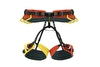

Fully adjustable harness with four buckles, ideal for mountaineering, winter climbing and via ferrata.


Organic Merino Wool Skiing Socks, reinforced on the toe, heel and shin.
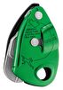

GRIGRI+ Climbing belay device with cam-assisted blocking and anti-panic handle, optimized for top rope climbing.
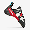

FURIA AIR continues to set the benchmark for climbing footwear, delivering exceptional sensitivity and an ultra-lightweight feel.
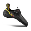

The La Sportiva Skwama Lite climbing shoes are designed for climbers looking to hone their technique and send hard, both indoors and outdoors.
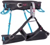

The Aurora is a top-level climbing harness designed specifically for women with special webbing that integrates breathable material with full strength strands for excellent breathability, good load distribution, and great packability.