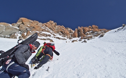
Grande Rocheuse Voie Originale, first ski and snowboard descent by Capozzi, Galli, Herry and Trento

 1 / 16
 © Davide Capozzi archivio
This winter didn't start out well for Davide Capozzi, Lambert Galli, Julien "Pica" Herry and Denis Trento. Little snow until mid-January, then finally the first abundant snowfalls onto the Mont Blanc massif. But as often happens, these snowfalls were followed by good weather but also warm conditions, meaning finding the right day to go out into the mountains was practically impossible. Stable conditions arrived in March and the low temperatures "allowed us" as Capozzi told planetmountain.com "to start thinking about doing something interesting…" This translates into the first ski and snowboard descent of the Voie Originale down the South Face of Grande Rocheuse, a magnificent summit in the Mont Blanc massif, perhaps slightly obscured by Aiguille Verte nearby. But this mountain peaks at an impressive 4102m and this descent follows a completely independent line, provoking the following reaction "Bravo, magnifique réalisation; il fallait avoir l’oeil." Which, written by Pierre Tardivel, is worth a thousand words.
GRANDE ROCHEUSE VOIE ORIGINAL di Julien Herry
Winter 2013, one of the most snowy of the past century, and for the first time I notice this obvious line on Grande Rocheuse. There's so much snow that it's clear to me it can be skied without using a rope. But there's too much snow even, we don't dare to give it a try. Easily visible from the top of Aiguille du Midi, it seems as if the route had never been climbed before and, even less so, skied. The only known ski descent from the summit was done in 1985 by Pierre Tardivel, by combining the South couloir of Col Armand Charlet...
The two following winters are drier and the route definitely not in condition. Then last summer Chamonix celebrated the 150th anniversary of the first ascent of Aiguille Verte. While reading an article about this feat, I saw a picture with the lines of the three new routes climbed in 1865. One of them followed exactly the route I imagined skiing... at first I was a bit disappointed, but then I discovered it made the project even more interesting; trying to follow the line of weakness discovered 150 years ago and now totally forgotten.
Fast forward to the end of January this year, conditions look promising and we start taking pictures from close up. Unfortunately there's no stable weather in February and we know from experience that the mountain dries quickly in March. While trying to forget this run, all of a sudden the weather forecast predicts a surprisingly stable and cold week. It's time to take our chance!
Sleeping in the Couvercle winter refuge with my friends Lambert and Manu, we wait for the Italian team to join us from the Torino hut. At 3.30 in the morning Davide and Denis join us for the 2-hour hike to the Bergshrund. Daylight reaches us as the first part of the couloir starts steeply. At this point Manu leaves us for his solo adventure in the Whymper couloir on the left.
The climbing gets steeper and steeper up the amazing snow spur. Unfortunately a thin layer of sugary snow covers some rocky slabs and what looks skiable from below turns out to be a pain to climb. Denis tries his luck by following the spur via what appears to be the most skiable line, but is forced to turn back. A short rappel and we try our chances just to the left, definitely not all skiable, but at least we can continue on up.
Above this a pleasant couloir leads us to more sugary snow loosely covering the rock below, but it's skiable nevertheless. Another short slope and the terrain obliges us to get the rope out for 30 more meters. Then all of a sudden we're on the final ridge, much shorter than expected, but as beautiful as in my dreams!
The four of us spend a few minutes on this narrow summit but the ascent was longer than expected and we now have to descend before it gets too warm. It feels like riding in the sky, high up there on the summit ridge, a few exposed turns are then followed by the first 30 meters rappel. The following turns are some of the steepest I've ever done, leading to the sugary crux where it's better to be the first to ski... After this the snow gets decidedly better, a kind of powdery spring snow, and once the 2nd rappel is done we can enjoy more speed and less exposure.
Back at the refuge we change our plans for another ski descent the following day. While examining the impressive photos, we feel like we've already taken enough risks on this trip and decide to ride back down to the valley. Back in 2013, when we skied the North face of Pain de Sucre, I tried to convince my Italian friends to ride all the way down to the valley but they preferred to save their skis by using the Montenvers train, and this disappointment had always frustrated me. Now though it was time to finish a great steep descent in my garden, despite being tired and carrying a heavy backpack, because there are not many places on earth where you can do this! And I hope there will be many more descents like this to come...
Grande Rocheuse 4102m
Voie originale 600m 45/50° max 55° - 5.4 - E4
Julien "Pica" Herry (snowboard)
Davide Capozzi (snowboard)
Lambert Galli (ski)
Denis Trento (ski)
| www | |
| FB Davide Capozzi | |
| picaguide.com | |
| www.snowhow.it | |


 Copia link


 See all photos


