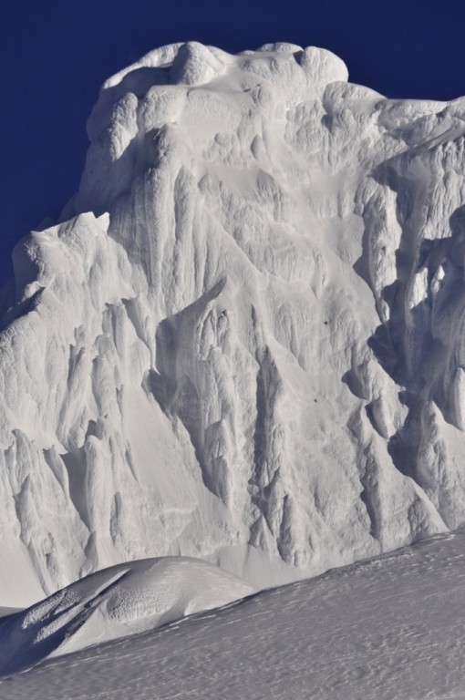
New route up Monte Sarmiento East: the second after this historic 1956 first ascent by Mauri and Maffei

 1 / 13
 Inés Duissallant / CORDARWIN.13
Why is Sarmiento such a magical mountain. Tell us more about its early history that makes it so legendary
Wow, that question could easily be the beginning of a new book! But I'll try to summarise... From what is known, Mount Sarmiento first entered our history books in the summer of 1579-80 when Pedro Sarmiento de Gamboa was sent to chase the pirate Sir Francis Drake at the Magellan Strait. Before that Mount Sarmiento was probably a central icon of the Yaghan and Selk'nam but all this was lost when these people were slaughtered. Sarmiento de Gamboa was very impressed by this mountain and he named it "Volcán Nevado" (Snowy Volcano). Since then and for more than a century the maps showed a mysterious volcano dominating the featureless and unexplored island of Tierra del Fuego, some times filled with drawings of giant Indians, often surrounded by marine monsters.
The British Admiralty explorations carried out between 1826 and 1836 unravelled the real topography of Tierra del Fuego, thanks in particular to the figures like Robert Fitz Roy, Charles Darwin and Phillipe Parker King. King realised that the "Volcán Nevado" wasn't a volcano after all and decided to rename it Mount Sarmiento, after its discoverer.
Thanks to proper charts and steam engines the Magellan Strait started a gold era and while thousands of travelers knew about this mysterious mountain, always hidden between clouds, only the lucky ones got a glimpse of it. All were astonished by the massive size of Mount Sarmiento rising 2200m straight from the sea: even by modern standards it is not easy to find something similar! It is a omnipresent sentinel mentioned in all exploration tales that talk of these remote lands, and it is also known also as a superb natural weather forecast: even today every fisherman in Magallanes knows that if Mount Sarmiento is visible, a storm is coming. Jules Verne, in his novel "Twenty Thousand Leagues Under the Sea" published in 1870, mentions the mountains forecast properties when the submarine Nautilus, navigating near Cape Horn, ascends to the surface and gets a clear view of Mount Sarmiento in the distance...
Then the time came for people to try and climb it
It was first attempted by Domenico Lovisato in 1882, but the first expedition set up with the aim of climbing Mount Sarmiento was in 1898, organised by Sir Martin Conway who came to America to climb Mount Aconcagua and Mount Sarmiento. This gives you an idea of the relevance of this mountain at that time. Although Conway failed, he discovered the best access route to the mountains upper reaches, the same that many followed, including us. You can find many quotes of travelers and explorers deeply moved by Mount Sarmiento's appearance but it was the Italian priest Alberto Maria De Agostini who got charmed the most. After three attempts between 1913 and 1914, at times spending up to two months on the mountain, he spent his life dreaming about "the ice sphinx" ("La Sfinge di ghiaccio"), and at the age of 73 he organized a big multidisciplinary expedition with the main objective of climbing Mount Sarmiento. For this he recruited some of the best Italian climbers at the time that included the likes of Carlo Mauri, Clemente Maffei, Luis Carrel, Luigi Barmasse, Camilo Pellissier and others. In total they spent 57 days on the mountain and after failing a few times on the north face, right at the last moment Mauri and Maffei launched a quick attempt along the south ridge, reaching the summit after a epic ascent enveloped in clouds and battered by strong winds.
And since then?
More than 20 expeditions have attempted the mountain, and while no one managed to reach the main summit, three succeeded on the lower West summit. Climbers have been attracted from every corner of the world including some of the world's best mountaineers such as Stephen Venables, Jim Wickwire, John Roskelly, Tim Macartney-Snape, Charlie Porter, José Carlos Tamayo, Iñaki San Vicente, César Perez de Tudela, Robert Jasper, Jörn Heller, Ralf Grantzhorn, Romolo Nottaris and the legendary Erhard Loretan among others. Every expedition enforced the reputation of this mountain, of its raging storms and vertical ice walls and whenever we thought of it we felt like David against Goliath. When we were invited along on the CORDARWIN.13 expedition to finally climb the mountain of our dreams we thought to ourselves: Well, we should at least try it, shouldn't we?
So tell us about this expedition. How did it come about?
Natalia and I have been going to Patagonia for many years, in my case my first expedition dates back to 1999 when I went to Volcán Melimoyu. A few years ago we decided to organise all our pre-expedition research which includes satellite pictures of the areas, the history, routes and summits reached by former explorers. In organising all of this we started a project we called UNCHARTED, the aim was to create maps of the most remote and unknown areas of Patagonia and track their history and heritage by adding all the names given by the explorers, the routes they followed, the countries they came from, the summits they climbed, etc... To do so, we contacted all the explorers that are still alive. And of course the idea behind all this was ultimately to also go and climb the most beautiful peaks of the area.
Hence Sarmiento!
In 2011 - 2012 we worked in the Cordillera de Sarmiento massif, a range 60 km west of Puerto Natales, a completely different area from Monte Sarmiento even though the names are confusingly similar! In mid-2012 we began working in Cordillera de Darwin. We were planning to attempt a few beautiful unclimbed peaks on the eastern tip of this range but we then received and invitation by Gonzalo Campos to go to Mount Sarmiento as his company Xplorator was organizing a non-profit, multidisciplinary expedition to this peak called CORDARWIN.13. This included artistic, scientific, sea exploration and mountaineering aspects that all shared the same logistics. We were obviously invited along to form the mountaineering team with the aim of reaching the main summit of Mount Sarmiento.
A fantastic objective!
Yes, we had dreamt of this for a long time. So we didn't think too much before accepting the invitation, as Sarmiento is such a legendary mountain, magic and full of history. We had read so much about it and while we were literally enchanted by this peak, at the same time we weren't sure whether we'd be up to the challenge. But we were certainly more than happy to give it a try!
Great. The time has come to tell us more about your partnership with Natalia...
Natalia and I have being climbing together for about 6 years, sharing expeditions to Nepal, the Southern Patagonia Ice Field, Cordillera de Sarmiento and Cordillera de Darwin. Our common desire to discover unexplored areas has pushed us into areas with extreme bad weather, which is the main reason why these have remained unexplored. Through experience we have learnt how to deal with the fierce Patagonian storms, how to set up camps and navigate in those conditions. I wouldn't say we have mastered it as there is so much more one can always learn, but definitely we now feel much more comfortable in bad conditions. I think out strongpoint is our motivation, our desire to get somewhere; Natalia always pushes very strongly towards an objective and as a team we don't give up easily unless there are some real safety issues. Another strong point are our navigation skills and our ability to progress even in bad weather, to not panic in strong winds or storms. To feel it as a part of the game, as a part of the mountaineering challenge, as a part of the mountains. Having said all of this, our weak point is probably our speed, I'd say that we are a rather slow team.
So now tell us more about your adventure on Monte Sarmiento
It was a extremely anomalous Patagonian expedition: we are used to running out of time attempting climbs, but this time everything was so quick, we barely could believe it. We had 30 days for the expedition, starting on August 11th, but we were delayed by bad weather for a week before leaving Punta Arenas. Supported by Inés Duissallant (she helped us carrying the loads, took photos and took care of the camp while we climbed etc.) we finally reached base camp on the 19th and we knew we were in a rush because the forecast had predicted a weather window on the 23rd. We carried loads on the 20th, in strong winds and very poor visibility, and the set off on the 21st aiming to reach High Camp but a strong storm stopped us at our cache at 870m. Winds gusting at over 120 km/h forced us to build a small snow cave where we spent the night. This messed up our planned schedule but it looked as if the weather window might take longer to come than predicted. On the next day (22nd), we ascended to high camp at 1216m in very limited visibility and spent several hours building a decent campsite.
Where you spent the night?
Yes, and the next day, the 23rd, the weather was perfect, blue sky and no wind, a dream! For safety reasons though on our first load we only ever carry the absolute necessities for survival (food, fuel, etc.) which meant that all the climbing gear was down in the cache. So even though we were desperate to climb and take advantage of the weather, we had to descend to pick up the climbing gear.
That certainly wasn't the best of fun...
We were quick and then we went to bed early to start our summit push at 3am of the 24th. We planned to hit the bergschrund at sunrise and this is exactly what we did. The bergschrund is located at circa 1800m, leaving us with about 400m of climbing. The crux of the entire route was here, a 5 metre section of overhanging ice covered with a thick layer of rime. After failing to climb this with ice axes, we switched techniques and aid climbed, using only ice screws and a shovel to breach it.
Then you had to do all the rest
Then was followed by 8 pitches of sustained 65-75° climbing, with some short steps up to 85-88°, up ice which proved very good for our ice axes but not so good for protection: placing ice screws was slow as we had to clean large sections before finding ice that was solid enough for the screws.
By this time it must have been getting late
Well, the short Patagonian winter day ended on the 7th pitch and we did the last section of the climb at night. The key to the route was a gully located behind a rime mushroom; completely hidden of the view, we just guessed that it was there and were really pleased when we discovered it existed after all! The route would have been blocked at the top by very difficult ice, but this gully led easily to the summit mushroom.
Tell us about the summit
We reached the top at 10:45pm. In fact there are were two summit mushrooms, both easy to climb and we obviously climbed both. The GPS read 2201m on the western one and 2207m on the eastern one which is true summit of Mount Sarmiento, 60 metres higher than the West summit. At the base of the summit mushroom an orange moon rose above a clear horizon - it was a surreal view, but the rest of the sky was already covered by clouds. We rappelled down the wall using snow pickets, V-threads and ice screws, reaching the Bergschrund at sunrise once again. We arrived back at high camp at 10am of the 25th, in zero visibility conditions and guided by the GPS.
Can you tell us more about these extreme conditions?
As usual in Patagonia, apart from the technical difficulty of a climb, the biggest difficulties are connected to the wind and navigating in low or zero visibility conditions. Conditions can obviously change very quickly: on our approach we encountered abundant, deep powder snow and we used our G3 skies basically all the way from the forest to the Bergschrund, while three weeks earlier a different team belonging to the same CORDARWIN.13 expedition encountered practically no snow and reached the same point as our High Camp on foot.
57 years for a second ascent… why do you think it took so long?
Difficult to say, in most cases the poor weather played an important role, but some expeditions had excellent weather windows and have failed in to find the route or just aborted due to problems with the expedition members. I guess our experience in Patagonia made us realise long ago that you have to move and hold on even in the worst weather in order to be in a position to climb when the weather window finally arrives. Sometimes though one needs to climb even in pretty bad weather if necessary, as we did last year on Cordillera de Sarmiento, were out of 25 days we had only circa 8 hours of windless blue skies.
So now that you have climbed Monte Sarmiento, what can you tell us about the first ascent of Carlo Mauri and Clemente Maffei 57 years ago?
We have nothing but admiration and deep respect for Mauri and Maffei. Reading Maffei's narration of the ascent you can really feel the deep commitment and the intensity of the emotions involved in that ascent. They risked everything for that summit. The lack of modern navigation tools made it an extremely committed ascent and the lack of modern ice climbing gear (short banana blade ice axes, crampons with frontal points and ice screws) made it way more difficult, being with no doubt a superb achievement for that time. We graded our route D+, perhaps it's MD, nothing extraordinary nowadays and I think their route was probably of similar difficulty but back then this was a outstanding climb. This mountain changes so much that we will never know exactly what the terrain they climbed was like, but no doubt theirs was an extraordinary climb that will always be remembered.
Out of interest, why didn't you go for their line?
They attempted the north face as we did, because they knew it offered the easiest terrain to the upper walls. In fact, from where the snow starts all the way up to the rime ice at 1800m we never had to take our skis off. One of the main reasons why they abandoned that route were the continuous avalanches and the falling ice, so they opted for the south face as this would offer safer and better ice conditions since it receives almost no sun, all year round. We selected our line as we thought it was simply the most beautiful unclimbed line on the mountain, a direct way up the north face. Since we were attempting it in mid-winter we expected better conditions than the ones they had encountered in the late summer of 1956.
While you did do a new route, you didn't reach a virgin summit and there have been other expeditions to the nearby West Summit. So how "exploratory" was this expedition?
I love exploration and I hope to continue exploring new areas, but this wasn’t really an exploratory expedition, we followed the most common access route to the mountain and we only got into virgin terrain up the last 400 meters. Nevertheless this was a deep and intense experience I'll never forget, being there was a dream. And after all I think we found the best access to the summit, we tried a face everyone had seen but nobody thought was feasible. If Mount Sarmiento will ever have a route you can define as the "normal route" I'm pretty sure it's going to be "Suerte de Sameinto".
So how would you sum it up this time
The weather was as usual, stormy, very windy and with plenty of snow fall and bad visibility. But on the 24th and 25th there was a superb weather window, with no or little wind and clear blue skies...thankfully previous days' fight against the bad weather placed us in just the right position to make use of that window. For one of the most amazing climbs I've ever done!
Thanks to the sponsors G3 and Outdoors Research
Links: www.unchart.org www.facebook.com/patagonia.uncharted
Organised by: Gonzalo Campos di Xplorator
Expedition leader: Gonzalo Campos Santa María
Logistics and support: Sergio Mauricio Godoy, Francisco Canales
Science team: Alfredo Soto Ortega, Eñaut Izaguirre Estibaritz, Inti Gonzalez Ruiz, Jorge Arigony, Juan Carlos Aravena Donaire, Pamela Nicol Soto Rogel, Ricardo Jaña
Documentary team: Amador Providell, Carolina Castro, Diego Pequeño
Mountain team : Natalia Martinez, Ines Dussaillant, Camilo Rada Giacaman
Kayak team: Cote Marchan, Rodrigo Bahamondez
Photographer: Guy Wenborne
Thanks to the sponsors G3 and Outdoors Research
| www | |
| Facebook Uncharted | |
| www.unchart.org | |


 Copia link


 See all photos


