Tre Cime di Lavaredo - Tre Cime di Lavaredo

 Copia link
 Enrico Maioni, Guida alpina


 1 / 12
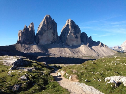
Tre Cime di Lavaredo: The magnificent Tre Cime di Lavaredo
 Planetmountain
Beauty

By
Enrico Maioni, Guida alpina
Length
9.5 km
Ascent height difference
405m
Descent height difference
410m
Difficulty
3,20 hours circa
The walk around the Tre Cime di Lavaredo is one of the most beautiful and famous walks in the world, best avoided in summer due to the large number of tourists.
Access
There are three main ways to reach the Tre Cime di Lavaredo: Cortina d'Ampezzo, Auronzo and Toblach. From each of these you have to reach Misurina:
from Cortina drive over Passo Tre Croci via the SR 48; from Auronzo take the SR 48 to Misurina; from Toblach take the SS 51 Alemagna, turning off left (east) at Carbonin, and continue along the SS 48a.
From Misurina take the toll road (outrageously expensive, 22 Euro per car in summer 2014) and drive up the southern slopes of the Tre Cime. Park close to Rifugio Aurono, where the road ends.
NotesTIMES AND DISTANCES
From Rifugio Auronzo to Rifugio Lavaredo 30 min ca. – 1,7 km
From Rifugio Lavaredo to Forcella Lavaredo 20 min ca – 1,0 km (road)
From Forcella Lavaredo to Rifugio Locatelli 40 min ca - 1,9 km (road)
From Rifugio Locatelli tp Malga dei Pastori 1,15 ora ca - 2,8 km
From Malga dei Pastori to Rifugio Auronzo 35 min ca - 2,1 k
HUTS
Rifugio Auronzo: Tel. +39 0435 39002Rifugio Lavaredo: Cell. +39 349 6028675
Rifugio A. Locatelli (Dreizinnenhütte): Tel. +39 0474 972002
Langalm – Capanna dei Pastori


 See all photos
 Comments
No comments yet...
Beauty
By
Enrico Maioni, Guida alpina
Length
9.5 km
Ascent height difference
405m
Descent height difference
410m
Difficulty
3,20 hours circa
Routes in the same mountain group
Related news
22/08/2014 - Trekking
Tre Cime di Lavaredo, Dolomites Enrico Maioni, Cortina Mountain Guide, introduces the walk around the Tre Cime di Lavaredo - Drei Zinnen - in the Dolomites, one of the most beautiful and famous hikes in...