Sas de Putia circular walk - Sas de Putia

 Copia link
 Planetmountain.com


 1 / 27
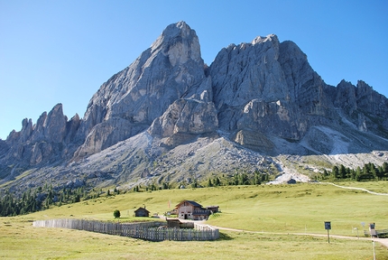
Sas de Putia circular walk: Sas de Putia and the hut Munt de Fornella
 Planetmountain
Beauty

By
Planetmountain.com
Orientation
N, S, E, W
Length
13km
Ascent height difference
300m circa
Descent height difference
300m circa
Time
5 hours circa
Popularity
High
Departure
Würzjoch
Arrival
Würzjoch
The Peitlerkofel circular walk it is a beautiful hike in the Puez-Odle Natural Park, Dolomites, that leads without major difficulties in circa five hours around the entire base of this 2875 high mountain which, in Italian, is called Sas de Putia.
The park is a UNESCO World Heritage Site and because of the walk’s beauty and the moderate height gain it is extremely popular, in particular the first section that leads from the Würzjoch pass to the col Forcella Putia where another path leads to an easy equipped path and the summit of Peitlerkofel, not described here.
The walk can be carried out in both directions. It is usually done counterclockwise, i.e. initially walking west, as this tackles the relatively steep ascent to Forcella Putia with fresh legs. Here though it is described in a clockwise direction, as this ensures you’ll be alone for as long as possible and you’ll be able to watch the early morning light unfold onto the different sides of the mountain.
Getting there
From Bolzano take the A22 towards Brenner, exit at Chiusa - Val Gardena, then drive up Val di Funes via the SP163 to Würzjoch / Passo delle Erbe (2008m). Alternatively, from San Martino in Val Badia follow the SP 29 to the pass. Park here. Itinerary
From Würzjoch follow the obvious path #8a which leads in about 20 minutes to the picturesque mountain hut "Munt de Fornella" (2067m) directly below the beautiful North Face of Peitlerkofel.
From here continue leftwards following the path #8b that leads east, at first through the woods to the hut Ütia Göma, then slightly uphill past beautiful meadows to the the Göma col (circa 1 hour 20 minutes from Würzjoch). From here the view onto Val Badia, protected by Sass de la Crusc, is splendid.
Now the path #35 leads easily to undulating and amazingly kept "prati del Putiax" alpine meadows and the Ütia Vaciara hut below the south face of Peitlerkofel. Path #35 begins to ascend more steeply and joins #4. Take this to reach the Forcella Putia col (2357m). This is where the normal route leads to the summit of Peitlerkofel, but the circular walk continues by descending steeply down the scree filled gorge along path #4 before reaching the Günther Messner Steig and path #8a.
To return to the starting point continue easily along path #8a back to leads to the "Munt de Fornella” meadows and the starting point. Notes
You need to pay to part the car park at Würzjoch / Passo delle Erbe. It is often extremely crowded and therefore highly recommended you arrive early. Maps/Bibliography
Tabacco N° 030 Bressanone Brixen-Val di Funes/Villnöss


 See all photos
 Comments
No comments yet...
Beauty
By
Planetmountain.com
Orientation
N, S, E, W
Length
13km
Ascent height difference
300m circa
Descent height difference
300m circa
Time
5 hours circa
Popularity
High
Departure
Würzjoch
Arrival
Würzjoch
Routes in the same mountain group
Related news
29/09/2016 - Trekking
Walking in the Dolomites: the Peitlerkofel circular walk The route description of the Peitlerkofel / Sass de Putia circular walk. An easy hike around one of the most spectacular mountains in the Dolomites.