Via Ferrata Oliva Detassis - Cima Brenta

 Copia link
 Planetmountain.com


 1 / 4
1 / 4
Via Ferrata Oliva Detassis: © Nicholas Hobley
 Planetmountain
Beauty


By
Planetmountain.com
Orientation
West
Ascent height difference
1400m
Ferrata height difference
200m
Height
2900m
Difficulty
Very Difficult
Time
3 hours from Rifugio Brentei to Rifugio Alimonta.
Period
June- October
Popularity
Medium
Route
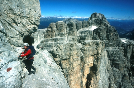
With its long and exposed series of ladders the “Oliva Detassis” is widely regarded one of the most difficult ferrate in the Brenta Dolomites. The itinerary is often cold and wet but it offers a rare and very particular view onto the wild valley and Vedretta dei Sfulmini glacier deep below. It is often climbed as the start, or the end, of the Bocchette Alte, but without a doubt it is to be considered a ferrata in its own right and not to be underestimated.
Getting there
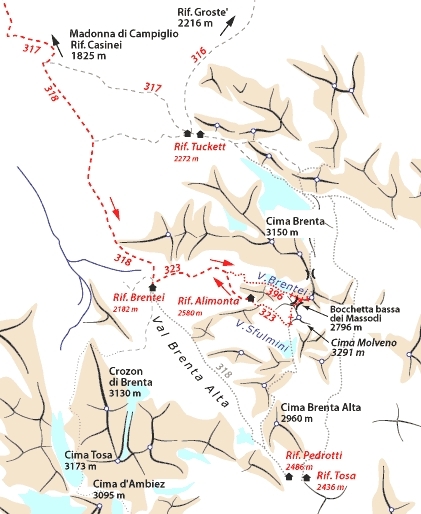
From Madonna di Campiglio drive to Rifugio Vallesinella (1513m). Access
From Rifugio Vallesinella (1513m) take path no. 317 to Rifugio Casinei (1825m) and then continue on path no. 318 Sentiero dei Brentei in two hours to Rifugio dei Brentei (2182m). Itinerary
From Rifugio dei Brentei climb up the wide gully keeping left, walk past the Sentiero Sosat fork and continue, following signs, up right. After about 50 mins reach the signpost for the Bocchette Alte and, instead of continuing up to Rifugio Alimonta, turn off left along path no. 396. This leads into the beautiful Vedretta dei Brentei valley. Traverse carefully along the right-hand side across small snow patches to reach the base of the ferrata. This is situated high to the right at the valley head and, given the danger of falling rocks, we recommend you wear your helmet well before reaching this start.
The ferrata begins immediately in earnest up steep ladders to gain height extremely quickly. Ledges offer welcome rest and view points onto the valley below, before continuing up rightwards past some wet cables (take care) to meet up with the Ferrata delle Bocchette Alte to the left of the exposed Bocca Bassa dei Massodi (2790m). Reach this by following the cables right (instead of following the other cables up north to the Bocchette Alte) and, having carefully crossed this col, climb up to Cima Molveno. Descend easily to the Vedretta dei Sfulmini glacier and Rifugio Alimonta (2580m).
Descent
From Rifugio Alimonta walk down the obvious and well-marked path to Rifugio dei Brentei, 2182m, in about an hour. Return to the Rifugio Vallesinella and the car park in a further 1.30 hours. Gear
Normal via ferrata kit. Ice axe and crampons necessary at the start of the season Maps/Bibliography
Via Ferratas of the Italian Dolomites: Vol 1 by John Smith and Graham Fletcher . Cicerone Press 2002 Difficulty
Extremely exposed itinerary up steep ladders. Well-equipped throughout.

 Comments
18/07/2003 Enrico Milanesio
Percorsa in discesa dopo le Bocchette Alte. Attenzione: forse a causa della nevicata del giorno prima su diverse scale nel tratto + in alto c'era una vera e propria doccia.
28/06/2002 Daniele Nocentini
Ho affrontato la via ferrata proveniendo dalle bocchette alte, quindi ho percorso il tratto in discesa, in pratica si tratta di una parte verticale di circa 120 mt fatta di scale e funi di acciaio. Si supera molto bene ed è emozionante scendere lungo la parete e vedere le roccie svrastanti che si ergono sopra la testa. Molto bella forse di più se si affronta dal basso verso l'alto.
Beauty
By
Planetmountain.com
Orientation
West
Ascent height difference
1400m
Ferrata height difference
200m
Height
2900m
Difficulty
Very Difficult
Time
3 hours from Rifugio Brentei to Rifugio Alimonta.
Period
June- October
Popularity
Medium
Route
Routes in the same mountain group